|
Technical Memorandum #1
Existing and Future Travel Demand Estimates
Introduction
Project
Description
The Ship Creek
Multi-Modal Transportation Plan is intended to be a long-range
infrastructure master plan for transportation that logically
integrates a number of individual development strategies for the Ship
Creek area. An implementation plan will also be developed that
identifies the physical improvements necessary to implement this plan,
an appropriate staging program for these improvements, and an
assessment of expected project costs.
The Ship Creek area lies
immediately to the north of downtown Anchorage. It is roughly bounded
by the downtown to the south (3rd Avenue), by the Port of
Anchorage to the north, by Elmendorf Air Force Base to the north and
east, and by Knik Arm to the west.
The Ship Creek area is a
truly multi-modal area in terms of transportation facilities and is
currently served by road, rail, seaport and pedestrian trails.
Automobiles, trucks, buses, bicycles, trains, ships and pedestrians
use these facilities. In the future, ferry transportation is likely to
be added to the mix of transportation modes in Ship Creek.
The major roadways serving
automobile, truck, and bus traffic into and out of the Ship Creek area
include the A/C Street couplet which traverses the area on a viaduct,
North C Street, Ocean Dock Road which provides primary access to the
Port, Whitney Road, West Bluff Road, Ship Creek Avenue (formerly
Warehouse Avenue) and Post Road. Each of these surface streets is a
two-lane facility with stop-controlled at-grade intersections.
The Alaska Railroad is a
major component within the Ship Creek vicinity, traversing the area
with lines running north to Fairbanks and south to Seward. A railway
station is located in Ship Creek on Ship Creek Avenue.
Trip
Projection Methodology
This memorandum presents
the results of the first phase of the Ship Creek Multi-Modal
Transportation plan which includes an evaluation of existing
multi-modal transportation facilities, land uses, mode conflicts and
estimated traffic volumes by mode. The task also included projections
for year 2023 travel demand by travel mode. These projections were
made by applying appropriate growth rates to existing traffic volumes.
Growth rates were determined by information provided in interviews
with a number of transportation facility users in the area and are
based on three different development scenarios encompassing low,
medium and high growth scenario assumptions.
Existing
Conditions
The
development of a comprehensive transportation plan begins with an
assessment of the existing traffic conditions within the study area.
This data provides an inventory description of the existing
traffic volumes while setting the stage for a basis of comparison to
future conditions.
For the
purposes of this study, information is needed that describes the
various types of travel modes, how each of the local businesses
utilize each of the travel modes, when they utilize each travel mode,
and how they plan to use these modes in the future. To obtain a
reasonably accurate assessment of the existing transportation facility
usage, a majority of the larger businesses that are currently
operating along the major roadway corridors within the Ship Creek
study area were surveyed. These
roadway corridors include the A/C Street couplet, North C Street,
Ocean Dock Road, Whitney Road, West Bluff Road, Ship Creek Avenue, and
Post Road.
Northern
Economics conducted a field study to develop a representative sample
of businesses and organizations along these Ship Creek roadway
facilities. As a result
of the field study, the names of the majority of Ship Creek businesses
and organizations were obtained and categorized according to location
by roadway facility as shown in Table 1.
Using this list of 44 businesses and organizations, an attempt
was made to contact a representative from each business. During the
interview process, the interviewee was asked to provide the following:
-
A description of the various travel modes utilized on a
daily basis;
-
an estimate of the daily and hourly volumes associated with
each mode;
-
a description of the peak operating characteristics of each
mode by month, day, and hour;
-
a description of the transportation facilities utilized;
-
potential growth rate estimates for each travel mode; and
-
a description of any foreseeable events that may affect the
existing or future travel volumes by each mode.
A sample survey questionnaire
is located in Appendix A. Based
on the results of the survey process, a comprehensive listing of
travel modes, traffic volumes, traffic distributions, and growth
projections were obtained for each Ship Creek business.
A description of the results is presented in the paragraphs
below.
Table
1
Ship
Creek Businesses and Organizations
| List
of Interviewees
|
|
1st
Avenue
|
| World
Trade Center |
Alaska Mill and Feed |
| The
Nature Conservancy |
Consolidated Freightways |
| Fleenor
(Paper Co.) |
|
|
|
|
|
Ship Creek
Avenue/Warehouse Avenue/Western Drive
|
| Alaska
Railroad Corporation Headquarters |
Anchorage Trade Center |
| Comfort
Inn |
Great Western Chemical |
| The
Ulu Factory |
Municipal Light and Power (ML&P) |
| Borealis
Brewery |
Allied Van Lines/Continental Moving |
| Glass,
Sash, and Door Supply |
Firestone/Cobre Tire |
| Brady’s
Floor Covering |
ANCO Shipping |
| Alaska
Insulfoam Corporation |
Northland |
| Summit
Paving |
|
|
|
|
|
Post Road
|
| Alaskan
Plumbing and Heating / EJ Company |
Commercial Truck Service |
| Arrow
Moving and Storage |
Jackovich Equipment Leasing |
| Auto
Electric |
Longstaff Engineering and Construction |
| Northland |
|
|
|
|
|
Whitney Road
|
| Alaska
Sheet Metal Inc. |
EJ Bartells |
| CAT
Transportation |
LaidLaw Transit |
| Craig
Taylor Equipment |
|
|
|
|
|
Ocean Dock Road /
West Bluff Drive / Port Road / Tidewater Road
|
| Inlet
Petroleum |
TOTE |
| Port
of Anchorage |
North Star |
| Sea-Land
SVC Inc. |
Williams Energy Services |
|
|
|
|
Other
|
| Government
Hill Residents |
Holland Cruises |
| Elmendorf
Air Force Base |
Princess Cruises |
| Beans
Café (and Outreach Center) |
People Mover |
| Brother
Francis Shelter |
Alaska Fish and Game |
|
|
|
Results
From the Ship Creek
business/organization survey, aggregate traffic volume data was
obtained for each travel mode during the peak individual operating
time periods. Based on
this data, a determination was made as to which time of the year,
which day of the week, and which hour of the day was likely to
experience the heaviest traffic volumes.
Our analysis showed that the peak travel month occurs during
the summer, and probably during the month of June or July when the
combination of tourist traffic and Ship Creek fishing is heaviest.
From a day-of-week perspective, Tuesday appears to experience
higher than average traffic volumes.
This situation can be attributed in part to the activities of
the Port of Anchorage, which schedules container ship deliveries
throughout the day. During
a July Tuesday, therefore, the peak traffic hour was found to occur
during the early evening time period, particularly between the hours
of 3:00 p.m. and 6:00 p.m. Based
on a comparison of past traffic counts conducted by the Alaska
Department of Transportation and Public Facilities in 1997 and 1998,
it was determined that the peak daily traffic occurs between the hours
of 4:00 p.m. and 5:00 p.m. A
summary table of the peak hour traffic volumes by mode and roadway
facility is shown in Table 2. Figure 1 graphically illustrates these
same traffic volumes according to the respective roadway facilities.
Table 2 and Figure 1 provide an estimate of traffic volumes that can
be expected to occur during a Tuesday evening peak hour in July.
Table
2
Existing
Peak Hour Traffic Volumes by Mode and Roadway Facility
| Roadway
Facility |
Volume1
|
|
Truck
|
Auto
|
Bus2
|
Total
Road Traffic
|
Rail3
|
Pedestrian
|
| A/C
Street |
350
|
1305
|
15
|
1,670
|
0
|
5
|
| North C
Street |
100
|
450
|
10
|
560
|
2
|
290
|
| Port
Access |
205
|
235
|
0
|
440
|
0
|
N/A
|
| Ocean
Dock Road |
160
|
190
|
5
|
355
|
6
|
0
|
| Whitney
Road |
45
|
260
|
25
|
330
|
0
|
235
|
| West
Bluff Road |
5
|
80
|
5
|
90
|
0
|
N/A
|
| 1st
Avenue |
50
|
195
|
10
|
255
|
0
|
10
|
| Ship
Creek/Warehouse Avenue |
5
|
280
|
0
|
285
|
0
|
220
|
| Post
Road |
95
|
470
|
0
|
565
|
0
|
N/A
|
1 The
volumes in Table 2 reflect only traffic volumes generated by sampled
Ship Creek businesses.
2
Represents city transit buses, tour buses, and school buses operated
by Laid Law
3
Indicates the number of trains crossing each roadway facility.
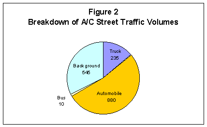
The truck, automobile,
bus, rail, and pedestrian traffic volumes shown in Table 2 reflect
volumes that are being generated solely by the sample of Ship Creek
businesses and organizations. Given
the nature and level of use associated with A/C Street through the
Ship Creek vicinity, this roadway link is expected to experience a
significant amount of background traffic.
For the purposes of this study, background traffic is defined
as the traffic that is not directly associated with Ship Creek, but
may be passing through such as commuters, delivery trucks, and
visitors to and from the Government Hill residential area. As shown in
Figure 2, this background traffic accounts for 545 vehicle trips
making up approximately 33 percent of the total roadway traffic on A/C
Street.
Along with truck,
automobile, and bus traffic, rail traffic volumes are an important
transportation element within the Ship Creek vicinity.
Since rail cars operate within their own right of way, the only
interaction these trains have with regular street traffic occurs when
rail line cross the street network.
Depending upon the length of the train, motorized vehicle
traffic will experience varying degrees of delay at the rail crossings
resulting in undesirable traffic operations.
Survey results indicate that as many as eight trains during the
peak hour can cause truck and automobile delays, hampering the smooth
and efficient operation of traffic along N. C Street and Ocean Dock
Road. Of particular
significance, the railroad tracks along Ocean Dock Road cross the
roadway in several locations, resulting in numerous vehicle/train
interaction points. During
the identified peak time period, this can result in approximately 6
vehicle/train delay points. Extremely
long trains with numerous boxcars can cause even longer vehicle
delays.
Table 2 also includes
estimates of pedestrian volumes along or across the study roadway
facilities. Many of the pedestrians are fishermen who fish between the
Knik Dam and the Mouth of Ship Creek. According to the Alaska
Department of Fish and Game, on average there are about 750 anglers
per day. In addition to the anglers, there are likely to be a number
of other pedestrians, including friends and/or family members of the
anglers, other tourists, and Alaskans who are in the area for business
or pleasure. Anecdotal reports indicate as many as 150 non-anglers may
be present at any given time. Pedestrian activity is concentrated from
the Knik Dam to the mouth of the creek and between the creek and
various parking lots. Volumes reported include pedestrian crossings of
North C Street as well as pedestrians walking along Whitney Road and
Ship Creek Avenue. Additional
pedestrian activity occurs along A/C Street and Ocean Dock Road as
Government Hill residents and Port workers often venture into the
Downtown Anchorage area.
Other significant
pedestrian generators in the area include Bean's Café/Brother Francis
Shelter which serves 800 people per day on average at 8 a.m. and noon.
The proposed Ship Creek Trail, which based on trail usage at the
nearby Coastal Trail, can be anticipated to generate 500 to 1,000
users per day in the area between Knik Dam and Reeve Boulevard. As an
aside, future trail development activities are expected to include the
construction of 20 new parking stalls at Viking Drive between Orca
Street and Concrete Street.
Although it is possible to
determine a peak hour based on traffic volume counts, a number of
other times of significant transportation activity were also
identified. Traffic conditions in each of these other time periods may
also need to be considered (in at least a qualitative manner) during
the development of the Ship Creek Multi-Modal Transportation Plan. A
description of some of these high-activity times is provided below:
-
Passenger trains bringing cruise passengers to and from
Anchorage arrive and depart during summer morning and evening
hours, typically around 6:45 a.m., 8:15 a.m., 10:00 a.m., 8:15 p.m,
9:45 p.m., and 10:25 p.m. These trains are usually met by tour
buses, taxis, and hotel shuttle buses to transfer passengers to
Anchorage hotels. Anywhere from 15-30 tour buses, and 250-300
taxis, personal automobiles, and hotel shuttle buses meet each
train. During these
times, there is significant pedestrian activity occurring in front
of the depot and along the adjacent roadways such as 1st
Avenue and N. C Street.
-
Heavy automobile volumes are experienced when Anchorage
fishermen drive to Ship Creek to fish for salmon in June, July and
August. These trips often coincide with high-tide, and especially
after work hours in the early evening.
-
A school bus yard located in Ship Creek serves the
Anchorage School District. As a result, high school bus volumes
are experienced in early morning hours and again around 4:00 p.m.
on school weekdays. In this regard, summer volumes are
significantly lower than when school is in full session.
Based on typical ratios of
peak hour-to-daily traffic volumes for the Anchorage area, approximate
daily traffic volumes were generated from these peak hour estimates.
These daily volume estimates are provided in Table 3.
Table
3
Existing
Daily Traffic Volumes by Mode and Roadway Facility
| Roadway
Facility
|
Truck
|
Auto
|
Bus
|
Total
Road Traffic Volume
|
| A/C
Street |
3,500
|
13,050
|
150
|
16,700
|
| North C
Street |
1,000
|
4,500
|
100
|
5,600
|
| Port
Access |
2,050
|
2,350
|
0
|
4,400
|
| Ocean
Dock Road |
1,600
|
1,900
|
50
|
3,550
|
| Whitney
Road |
450
|
2,600
|
250
|
3,300
|
| West
Bluff Road |
50
|
800
|
50
|
900
|
| 1st
Avenue |
500
|
1,950
|
0
|
2,450
|
| Ship
Creek/Warehouse Ave. |
50
|
2,800
|
0
|
2,850
|
| Post
Road |
950
|
4,700
|
0
|
5,650
|
These estimated
volumes may be used to compare to estimates for daily trip capacities
for each facility to develop an assessment of the operational
sufficiency of each facility.
Future
Projections
The future truck,
automobile, bus, rail, pedestrian, and bicycle traffic projections
listed in this report were based on the existing traffic volumes that
were assembled from the survey process.
It should be noted that these future projections are based on
expected growth associated with the existing businesses located within
the Ship Creek study area. As part of the next phase of this study,
these future projections will change as a more detailed analysis is
conducted. This will take into account the traffic growth associated
with the following planned developments:
- 2001
or 2002 ferry service
- 2010
commuter rail service from the Mat-Su borough
- 2005
rail service to/from cruise ships in Seward and Whitier
- Planned
expansions identified in the Regional Port of Anchorage Master Plan
- Mixed
land use developments that have been identified in the Alaska
Rail Road Corporation Ship Creek Master Plan
Methodology
Future travel growth
assumptions for year 2023 conditions were based on a forward
projection of existing traffic volumes according to the three growth
assumptions investigated as part of the interviews conducted with area
businesses. As part of the interview process, each business
representative was asked to provide annual traffic growth rate
estimates for three scenarios: low; medium and high growth through
2023. Clearly, many of the interviewees do not typically work in the
arena of long-range planning, especially in travel forecasting, so
many of them had difficulty estimating a reasonable 20-year growth
projection. Consequently, many of the interviewees quoted growth rates
from shorter-term plans (typically, 3-, 5- or 6-year plans). In such
cases, these shorter-term growth rates were used as the basis for the
2023 projections developed in this study.
The growth rate estimates
obtained were compared with different growth scenario estimates
developed as part of other formal planning studies in the Ship Creek
area. These include plans developed for the Alaska Rail Road
Corporation and the Port of Anchorage in recent years (References 1
and 2).
Description
of low, medium and high growth scenarios
Based on the ranges of
annual growth rates obtained in the interview process for this study
and a comparison of these rates with growth scenarios from other
formal studies in the Ship Creek area, the three growth scenarios
developed for this study are shown in Table 4. Interestingly, these
projections seem to be quite consistent with those used in the Port
Master Plan, which also considered three growth scenarios ranging
between –0.1 % and 3.7 percent annual growth.
Table
4
Ship
Creek Growth Scenarios
|
Growth
Scenario
|
Annual
Growth Rate
|
Growth
Rate to 2023
|
|
Low
|
1
%
|
27%
|
|
Medium
|
2
%
|
61%
|
|
High
|
3
%
|
103%
|
As
indicated in the table, the low growth assumption results in a 27
percent growth by 2023. The medium growth scenario reflects a 61
percent growth while the high growth scenario leads to traffic volumes
doubling with a 103 percent growth.
Year
2023 projections by mode and facility
Using the growth rates
shown in Table 4, existing traffic volumes were multiplied to produce
the results shown in Table 5 below.
Table
5
2023
Peak Hour Road Traffic Projections
| ROADWAY
|
LOW
|
MEDIUM
|
HIGH
|
| A/C
Street |
2,120
|
2,685
|
3,395
|
| North C
Street |
710
|
900
|
1,140
|
| Port
Access |
560
|
710
|
895
|
| Ocean
Dock Road |
450
|
570
|
720
|
| Whitney
Road |
420
|
530
|
670
|
| West
Bluff Road |
115
|
145
|
185
|
| 1st
Avenue |
310
|
395
|
500
|
| Ship
Creek/Warehouse Avenue |
360
|
460
|
580
|
| Post
Road |
715
|
910
|
1,130
|
As part of subsequent
project activities, these estimated future volumes will be compared
against the estimated capacity of each facility to determine the
overall operational sufficiency of each facility under each of the
different growth scenarios.
References
1.
Alaska Railroad Corporation.
Ship
Creek Development Master Plan.
January 1999.
2.
Port of Anchorage.
Regional
Port of Anchorage Master Plan.
August 1999.
|